


 04.08
04.08
 ridwan baihaqi

The Access Grid Node Listing lets one specify GPS coordinates of an Access Grid. These show up as a link to an appropriately centred Google Map. In future, GPS coordinates can be used for inferring time zones, drawing maps of world-wide Access Grid usage, etc. As we encourage all node listings to have accurate GPS coordinates, here's a guide to finding yours ... If you are already familiar with Google Maps and how to find your location at maximum zoom, skip to the final paragraphs of this document. Otherwise, open a web browser and go to Google Maps at the URL listed in the image below see label (1), http://maps.google.com. Google being a search engine, the simplest way of locating your city is to enter a "city, country" in the search box (2). Alternatively, you can self-navigate: Zoom in/out using the vertical slider adjacent to (3). Pan the image left-right-up-down, either using the buttons above (3) or by "clicking and holding" the left mouse button followed by mouse movement in the desired direction Before proceeding, press the "hybrid" button (4), requesting a combination of satellite imagery and local GIS data (roads, labels, etc.).

The author's node is located in Canberra, Australia. Entering this into the text entry box and pressing "Search" (5) immediately locates us above the Australian capital's core.

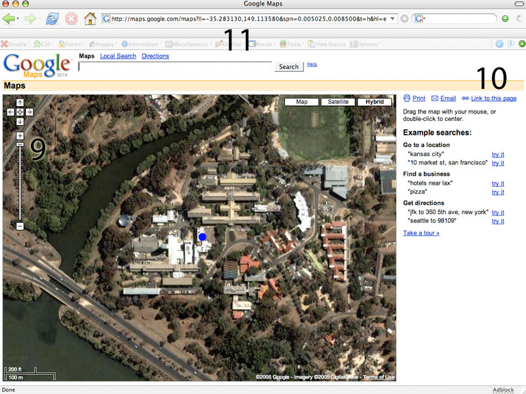
With our Access Grid location thus centred, it's time to extract the coordinates. If we select "link to this page" (10), the URL at top (11) changes to reflect our current location and zoom level. Extracting GPS Coordinates
http://maps.google.com/maps?ll=-35.283130,149.113580&spn=0.005025,0.008500&t=h
The desired GPS coordinates are embedded in the URL in "latitude,longitude" format. For the example above the latitude is -35.283130 and the longitude is 149.113580.
Ignore the other values, simply copy/paste the coordinates into your node listing's edit form where is asks for latitude and longitude, the below example is from the SMSCS Computer Science, New Zealand Node.

It's a simple as that.
Note: the latitude and longitude may appear after a long string of characters in the url. Look for the following part of the url "ll="the lat and long should be the next set of numbers.
SOURCE
 Posted in: Tutorials
0 komentar:
Posting Komentar